BONNEVILLE POINT WILDFLOWER WALK
mid May to mid June
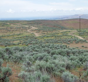
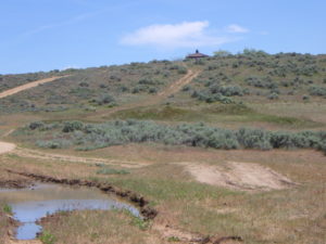
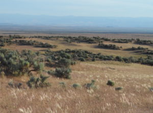
Description: This walk provides a very different experience from that of most trails in the Boise Front, exploring a section of the Oregon Trail on the edge of the Mountain Home desert to enjoy serene views, mid-season wildflowers, history, and maybe even a few pronghorn. The self-guided tour and plant list covers 2-3 miles roundtrip from Bonneville Point, with modest elevation loss and gain. The walk is on exposed tableland, so it is best to avoid extremes of either hot temperatures or the threat of thunderstorms.
To get to Bonneville Point, take the Blacks Creek exit (#64) on I-84 southeast of Boise; follow Blacks Creek Road east for about 2½ miles, then turn left on a well-signed road for another 1+ miles. There are often a few pronghorn visible along the route; always a treat to see! The road ends at a scenic viewpoint and interpretative area on the Oregon Trail, with expansive views across the Boise Valley and western Snake River Plains to the Owyhee Mountains on the southwestern horizon. The interpretive kiosk is in a fenced area with several sickly and dead honey locust (Gleditsia triacanthos), along with a few healthier black locust (Robinia pseudoacacia) with their clusters of fragrant white flowers.
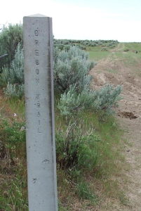 If you have not previously done so, be sure to take advantage of the interpretative signage, for what is essentially the starting point for the current city of Boise, which was, and remains, the largest city on the Oregon Trail between its beginning and ending points.. This is the approximate location where Captain Benjamin Bonneville’s expedition (romanticized by Washington Irving) had their first glimpse of the tree-lined river in the valley below in May 1933, after days of crossing the arid sagebrush plains from the east. Those of us who took Idaho history in 4th grade were taught how the French members of the expedition exclaimed “Les bois, les bois – voyes les bois (The woods, the woods – see the woods)!”. Although this episode is regrettably not mentioned by Irving, it nevertheless provides the apocryphal origin of the name Boise being applied to the river, and ultimately the “City of Trees” that grew on its banks. The interpretative signage provides additional history, from the indigenous inhabitats of the area (Shoshone, Bannock, Northern Paiute), to the fur trade, to Oregon-bound emigrant wagons following the same route as Bonneville’s expedition, which presumably took advantage of existing Indian trails.
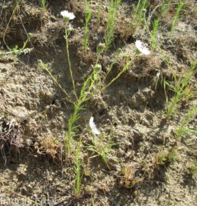
The wildflower walk described here does not follow a designated route, but rather addresses the most noteworthy habitats and plants that are likely to be encountered on whatever combination of the several intertwining roads one wishes to follow, heading gently downhill to the west and dropping stepwise onto successive terraces. The plant list goes for about 1 mile, where several roads intersect.
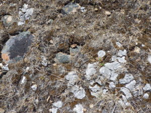
The geology on the south side of the Boise River is, with some exceptions, very different from that on the north side of the river. As a sweeping generality, the Boise Front is dominated by granite-derived soils and sediments of the Idaho Batholith, interspersed with some basalt volcanic features such as Chukar Butte. In contrast, recurrent. relatively young (less than 1½ million years old) basalt flows created the upland plateau that stretches from Boise to Mountain Home, now overlain by wind-blown loess soils and minor sediments in creek beds, including cobbles and sand from the granite batholith. Polished granitic cobbles are a dominant feature at Bonneville Point; it is possible that the Oregon Trail preferentially followed this natural “pavement”. And since plants are excellent geologists, you can find plants growing here that aren’t known from the Boise Front proper, notably hairy or Hooker’s balsamroot (Balsamorhiza hispidula) and bighead clover (Trifolium macrocephalum). Many of these are common to the south, including in the distant Owyhee Mountains, and in fact the Boise River is an approximate dividing line between major floristic regions: the Pacific Northwest/Rocky Mountain floras to the north, and the Great Basin/Intermountain Region flora to the south.
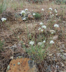
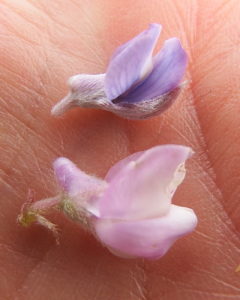
One of the most interesting habitats occurs near the beginning of the walk, north of the interpretive area. This is a cobbly scabland with well-spaced low-sagebrush (Artemisia arbuscula ssp. longiloba), which is not found elsewhere in the area covered by this website. Characteristic wildflowers of this habitat include several that would be suitable for rock-gardens, notably scabland fleabane (Erigeron bloomeri var. bloomeri) and ballhead sandworth (Eremogone congesta var. cephaloidea). Gumbo biscuitroot (Lomatium bicolor var. leptocarpum) is also locally common, but probably already in fruit at the recommended time for this walk. This is furthermore a good place to compare our two most common species of lupine, when their blooming times overlap. The flowers of the earlier blooming longspur lupine (Lupinus arbustus) come in many colors and have a pronounced spur, while the later-blooming silver lupine (Lupinus argenteus) has more uniformly blue-violet flowers that have only a slight bump; leaves of the silver lupine are generally also more silver-hairy.
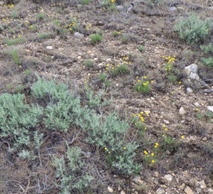
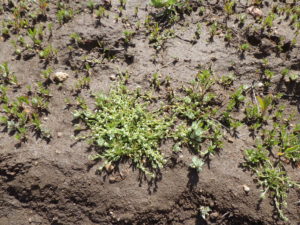
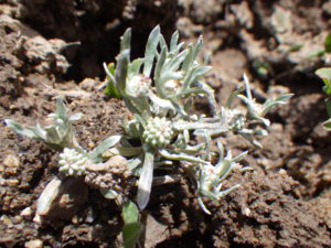
Additional wetland diversity exists around the pools that form in depressions on the roadbeds, indicating the prescence of an underlying hardpan that inhibits water percolation. Despite ubiquitous damage by motorized recreation, mudflats around the pools are an excellent place to look for several noteworthy native annuals, including two species of woolly-marbles (Psilocarphus), Great Basin pincushion plant (Navarretia propinqua), two species of popcorn-flower (Plagiobothrys), and lowland cudweed (Gnaphalium palustre). Smooth spike-primrose (Epilobium campestre) is often common, but the tiny pink flowers generally bloom later in the season.
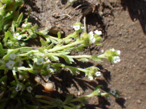
A very different habitat occurs on the slope southwest of the interpretive area, where a dark green swath of wiry-stemmed Baltic rush (Juncus balticus) marks a seasonal seepage area. In a good year (which 2020 is not), it can be worthwhile to spend some time looking for a variety of native annuals, including hairy own-clover (Castilleja tenuis), smallhead clover (Trifolium microcephalum), and even the intriguing pearlflower (Heterocodon rariflorum), which only rarely produces obvious (chasmogamous) bell-like flowers, relying otherwise on obsure cleistogamous flowers. In a good year, be careful to stick to the drier margins, so as not to trample tiny natives in their sensitive wetland habitat (unless cattle have beaten you to it).
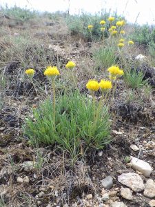
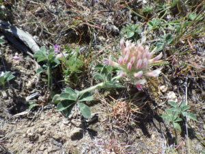
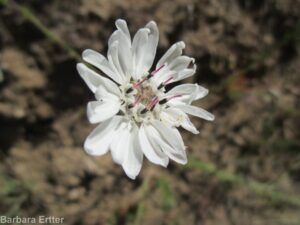
One intriguing landscape feature to note is the discernible mound-intermound topography, also referred to as Mima mounds. Although not as distinct as in some areas, where the regularly spaced mounds form patterns easily seen from airplanes, the contrast between sagebrush-covered mounds of relatively deep soil and the rocky flats in between is clearly evident. Several theories exist for the origin of this topography, but none have been confirmed. Among the plants to look for in the intermound habit is one of the most lovely, though rarely caught in bloom locally: bighead clover (Trifolium macrocephalum), which differs from most clovers in having more than three leaflets. This species is relatively common in the Owyhee Desert but not known from the Boise Front proper; the plants growing have paler flowers than is typical. Intermound flats are also good places to look for several annual genera in Asteraceae, including the relatively common eyelashweed (Blepharipappus scaber), the softly pubescent hareleaf (Lagophylla ramosissima), and the much harder-to-spot wireweed (Rigiopappus leptocladus). In addition, take note of the well-developed soil crusts comprised of mosses and lichens, some also growing on the abundant cobbles.
It is unfortunate that the seemingly bare flats of the intermound appear so inviting to ATV’s, since they not only host a nice selection of interesting wildflowers but also provide important ecological functions, including nutrient recycling and natural firebreaks. Intact soil crust is resistant to seed germination of invasive cheatgreass (Bromus tectorum), but repeated disturbance can result in the natural firebreak being replaced by solid stands of tinder-dry annual grass. Unregulated mechanized recreation has a long history of use in this area, but whether or not this remains the best possible use is a legitimate question, especially for a prime recreation site so accessible to a rapidly growing population.
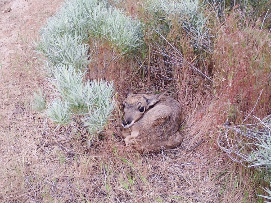
The open sagebrush-covered slopes and flats around Bonneville Point are also the most reliable place locally to look for pronghorn, the fastest land animal in North America. Although commonly called antelope, pronghorns are evidently more closely related to giraffes and okapis. These beautiful buff-and-white animals will see you long before you see them, depending on speed more than cover for safety (except for the fawns, which hide tucked among the brush).
PLANT LIST [updating needed]
NOTE: Please enjoy the wildflowers and leave them for others to enjoy. Because our unique local flora is already under pressure from invasive weeds and habitat loss, harvesting of native plants is not encouraged on this website, especially along popular trails.
Plants listed in alphabetical order of scientific name within category; * designates native plants
WILDFLOWERS POSSIBLY IN BLOOM (or fruit)
- *Yarrow (Achillea millefolium)
- *Tapertip onion (Allium acuminatum)
- *Fiddleneck (Amsinckia spp.) – species difficult to distinguish
- *Dwarf or low pussytoes (Antennaria dimorpha)
- *Woolly-pod milkvetch (Astragalus purshii var. glareosus)
- *Hairy or Hooker’s balsamroot(Balsamorhiza hispidula, aka B. hookeri var. hispidula)
- *Eyelashweed or blepharipappus (Blepharipappus scaber)
- *Gray-green thistle (Cirsium cymosum var. canovirens) – the only locally native thistle
- *Modoc hawksbeard (Crepis modocensis)
- *Western hawksbeard (Crepis occidentalis)
- *Ballhead sandwort (Eremogone congesta var. cephaloidea, previously in Arenaria)
- *Scabland fleaban (Erigeron bloomeri var. bloomeri)
- *Shaggy fleabane (Erigeron pumilus var. intermedius)
- *Proliferous or strict wild-buckwheat (Eriogonum strictum var. proliferum)
- Stork- or cranesbill, filaree (Erodium cicutarium) – non-native
- *Curly-cup gumweed (Grindelia squarrosa)
- *Hareleaf (Lagophylla ramosissima)
- Clasping pepperweed (Lepidium perfoliatum)
- *Stoneseed, Puccoon, Gromwell (Lithospermum ruderale)
- *Gumbo biscuitroot (Lomatium [bicolor var.] leptocarpum)
- *Narrowleaf biscuitroot (Lomatium simplex, previously included in L. triternatum, nine-leaf biscuitroot)
- *Longspur or polychrome lupine (Lupinus arbustus [= L. laxiflorus in older references])
- *Silver lupine (Lupinus argentea)
- *Nodding microseris or silverpuffs (Microseris nutans)
- *Pricklyleaf phlox (Phlox aculeata) intergrading with longleaf phlox (Phlox longifolia)
- *Cross-seed or slender popcorn-flowe (Plagiobothrys tenellus)
- *Woolly plantain, Indian-wheat (Plantago patagonica)
- *Wireweed, Rigiopappus (Rigiopappus leptocladus)
- Yellow salsify or goat’s-beard (Tragopogon dubius)
- *Bighead clover (Trifolium macrocephalum)
WETLAND PLANTS
- *Hairy owl-clover (Castilleja tenuis, previously Orthocarpus hispidus)
- Sticky chickweed (Cerastium glomeratum, previously C. viscosum)
- *Smooth spike-primrose (Epilobium campestre [= E. pygmaeum, Boisduvalia glabella])
- *Lowland cudweed (Gnaphalium palustre)
- *Heterocodon, pearlflower (Heterocodon rariflorus) – visible flowers uncommon
- Mouse-ear forget-me-not, blue scorpion-grass, (Myosotis micrantha [alt: M. stricta])
- *Great Basin navarretia or pincushion-plant (Navarretia [intertexta var.] propinqua)
- *Harsh popcorn-flower (Plagiobothrys hispidulus)
- Knotweed (Polygonum aviculare)
- *Round or short woolly-marbles (Psilocarphus brevissimus)
- *Oregon woolly-marbles (Psilocarphus oreganus)
- *Smallhead clover (Trifolium microcephalum)
- *Purslane speedwell, neckweed (Veronica peregrina var. xalapensis)
SHRUBS
- *Low sagebrush (Artemisia arbuscula)
- *Big sagebrush (Artemisia tridentata)
- *Rubber rabbitbrush (Ericameria [previously Chrysothamnus] nauseosa)
- [*Bitterbrush, Antelope brush (Purshia tridentata) – visible off to side]
GRASSES AND GRASSLIKE PLANTS (not all in bloom)
- *Thurber’s needlegrass (Achnatherum/Stipa thurberianum)
- Crested wheatgrass (Agropyron cristatum) – widely planted non-native
- Meadow brome (Bromus commutatus) – similar species also possible present
- Cheatgrass (Bromus tectorum) – major invasive species
- *One-spike oatgrass (Danthonia unispicata)
- *Squirreltail grass (Elymus elymoides, previously Sitanion hystrix)
- Mediterranean barley (Hordeum marinum ssp. gussonianum [= H. geniculatum])
- *Baltic rush (Juncus balticus)
- *Toad rush (Juncus bufonius var. bufonius)
- *Colorado rush (Juncus confusus)
- *Great Basin wildrye (Leymus/Elymus cinereus)
- Bulbous bluegrass (Poa bulbosa) – weedy non-native
- *Sandberg bluegrass (Poa secunda)
- Medusahead grass (Taeniatherum/Elymus caput-medusae) – major invasive species
- *Small fescue (Vulpia microstachys) – one of our only native annual grasses
- Rattail fescue (Vulpia/Festuca myuros)
SIGNIFICANT NOXIOUS WEEDS (not all in bloom, but evident)
- Bur buttercup (Ceratocephala/Ranunculus testiculata)
- Rush skeletonweed (Chondrilla juncea)
- St. Johnswort, Klamathweed(Hypericum perforatum)
- Whitetop (Lepidium [previously Cardaria] draba)