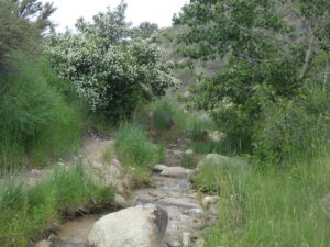
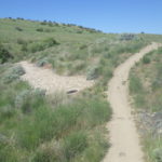
The lower half-mile of Bob’s Trail (#30), along East Crane Creek, is a delightful walk at most times of the year, harboring a surprising diversity of native wildflowers along its relatively short length. Separate walks are described for June, when the syringa and checkermallow are most likely to be in bloom, and early fall, when an entirely different suite of streamside plants are in bloom. The popular single-track trail is narrow and rocky in places, with three stream crossings that can be challenging at high water. Total distance covered by the plant list is a bit less than a mile (out and back); total elevation gain is 150-200 feet. Longer return loop options exist for those feeling more ambitious.

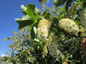
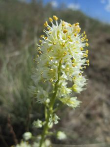
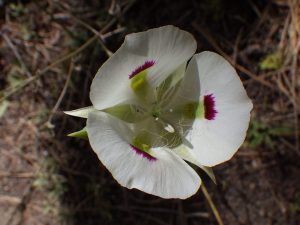
Description: The walk begins at trailhead at the north end of Hearthstone Drive (access via Curling Drive in the Highlands); be respectful of the neighborhood and obey posted speed limits. Follow the trail up East Crane Creek; guided wildflower walk and plant list cover about half a mile, to the junction with Urban Connector Trail (#9). The flowing creek (at least through spring), at the base of a steep north-facing slop, is largely free of a solid shrub cover and creates special conditions that foster the diversity of plants that makes this walk special. This is one of the easiest places to see an abundance of syringa or mock-orange (Philadelphus lewisii), Idaho’s state flower, and to enjoy its fragrant flowers. The site also provides a low-elevation refuge for some plants that normally occur at higher elevations, notably the wingfruit mariposa or sego-lily (Calochortus eurycarpus); if you are lucky, you might see a few of the purple-spotted white flowers scattered on the north-facing slopes. Although not visible from the trail, there is also a single outlying occurrence of starry sulphur-flowered buckwheat (Eriogonum umbellatum var. ellipticum), tucked under the lone cottonwood on the opposite side of the creek near the beginning of the trail.
As is obvious right from the beginning of the walk, the native diversity is matched by non-native diversity, and whether the latter will ultimately displace the former remains to be seen. In addition to the usual non-natives common at low elevations, several plants in particular are likely to trigger some curiosity, including a few red-orange flowers of long-headed poppy or blindeyes (Papaver dubium), probably originating from a “wildflower” seed mix, that can sometimes be seen near the trailhead. The distinctive purplish-leaved shrub right next to the trail is a form of cherry plum (Prunus cerasifera). Occasional plants of garden burnet (Poterium sanguisorba, previously Sanguisorba minor) provide an additional curiosity, as a very atypical member of the rose family with short spikes of highly reduced flowers; the edible leaves taste like cucumber.
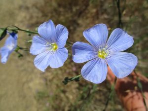
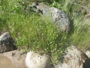
Young black cottonwood (Populus trichocarpa) are scattered along the creek, as are syringa, several species of willow (Salix), and a couple of species of non-native rose (Rosa canina and R. obtusifolia). Upland shrubs include not only the common foothill shrubs (sagebrush, antelope brush, rubber rabbitbrush), but also green rabbitbrush (Chrysothamnus viscidiflorus) with its corkscrew-twisted leaves, our native interior or Wood’s rose (Rosa woodsii ssp. ultramontana), golden currant (Ribes aureum), and several thickets of chokecherry (Prunus virginiana var. melanocarpa). The white spikes of chokecherry bloom earlier in the year, while the yellow heads of rabbitbrush won’t appear until fall. The young juniper (Juniperus) is presumably an escapee from cultivation, probably with the help of a bird, since native junipers are not known to occur naturally in the Boise Front (although common south of the Snake River Plains.) There are also a few large clumps of Great Basin wildrye (Leymus cinereus) on the north-facing slope, along with wildflowers such as longspur lupine (Lupinus arbustus; mostly past bloom), wild-hyacinth (Triteleia grandiflora), largeflower collomia (Collomia grandiflora) with its distinctive salmon-colored flowers, and many others, depending on the season. Perennial flax (Linum perenne), with its sky-blue flowers, is often conspicuous at the first creek-crossing. This widespread species is often included in wildflower seeding mixtures as the closely related Lewis’s flax (Linum lewisii), but it is actually a Eurasian species that differs in having heterostylous flowers (i.e., some plants with styles longer than the anthers, others with styles shorter than the flowers).
Take time to admire the plant diversity along the sandy, sunny, streambank, though several of the most interesting plants won’t be blooming until later in the season. Two small-flowered native annuals that might be starting to bloom are bird’s-foot trefoil (Acmispon americanus, previously Lotus purshianus) and smallhead clover (Trifolium microcephalum), both in the pea family. Several native grasslike perennials are also relatively easy to spot: straightleaf rush (Juncus orthophyllus), Douglas’s sedge (Carex douglasii), and common spike-rush (Eleocharis palustris). Conspicuous non-native perennials include curly dock (Rumex crispus), Bouncing bet or soapwort (Saponaria officinalis, probably not yet in bloom), and sulphur cinquefoil (Potentilla recta), which is a troublesome invasive species.
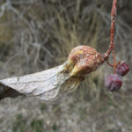
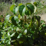
Coming up next is a grove of light green shrubs or small trees with a gnarled, contorted appearance; these are our native netleaf hackberry (Celtis reticulata). Their odd appearance is exacerbated by the presence of numerous leaf galls, which result when an insect not only lays its eggs on a plant, but then manages to co-opt the plant’s growth hormones to force it to grow a tailor-made nursery for the developing larvae. There are many different kinds of galls on different plants, each created by a specific insect, most often a wasp or fly.
A small sandy beach is on the other side of the second creek crossing, bring the path back to the base of the north-facing slope. If you are not already familiar with western poison-ivy (Toxicodendron rydbergii, previously included in Rhus radicans), take note of the colony at the edge of the beach. Unlike other kinds of poison-ivy and poison-oak, western poison-ivy is not a vine or large shrub. Instead, it forms an open patch of erect grayish stems, mostly less than three feet tall. In addition to the “leaflets three, let it be” identification refrain, even the leafless winter stems can often be recognized by clusters of dried white berries.
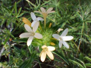
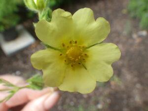
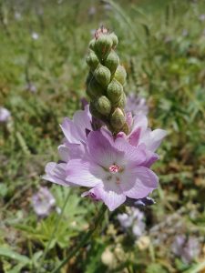
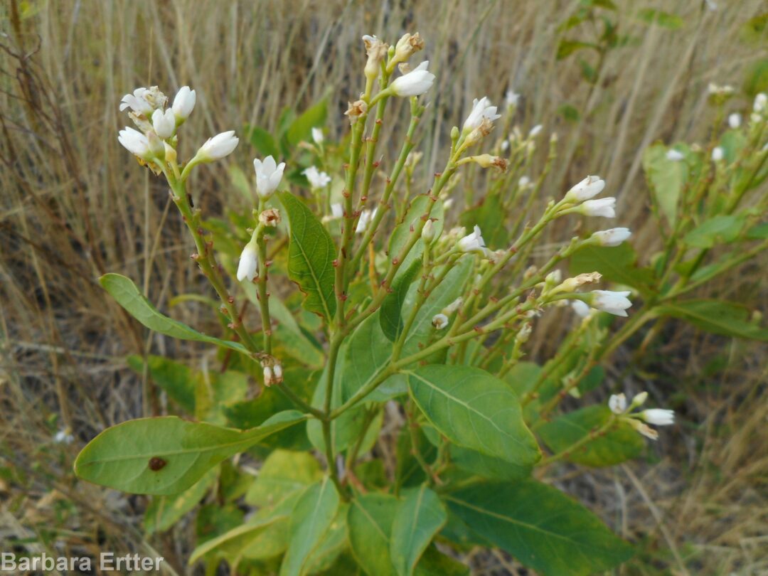
As the trail continues, keep an eye out for several additional perennial wildflowers along the edge of the creek and adjacent slope. If you’re lucky, you might catch foothill death-camas (Toxicoscordion paniculatum, previously in Zigadenus), wingfruit mariposa or sego-lily (Calochortus eurycarpus), Oregon checkermallow (Sidalcea oregana), and Nuttall’s cinquefoil (Potentilla gracilis var. fastigiata) in bloom. The Boise Foothills form of Oregon checkermallow differs from forms growing elswhere in having dense stellate (starlike) hairs on the stems and leaves; whether this has any taxonomic significance remains to be determined. A clump of Nuttall’s cinquefoil grows on the right side of the path opposite a small black cottonwood on the other side of the creek, shortly before the third (and final) creek crossing. This native cinquefoil, relatively uncommon in the Boise Front, has bright yellow petals and retains its cluster of dark green basal leaves. In contrast, the invasive sulphur cinquefoil has pale yellow petals, and the basal leaves generally shrivel by the time flowering begins.
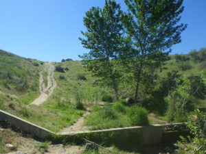
About 1/3 mile from the trailhead is a check dam, built in the mid 1990’s as a flood control measure after disastrous mudflows following major fires in the Boise Front (see Interpretative Loop wildflower walk, and “When the Pot Boiled Over”). Take time to appreciate the various construction features of this earth-fill dam, which was not designed to store water but rather to protect neighborhoods downstream by limiting maximum water flow and holding back mud and debris in case of future flood events. In this photo, the dam is the hill spanning the gulch in the background; the concrete structure in the foreground is a flow spreader/erosion catch, intended to keep floodwater from cutting the stream channel deeper and potentially undercutting the dam. Annual maintenance by the Department of Public Works is presumably the reason for the recent removal of some shrubs and small trees from this area. Fortunately the remaining trees continue to provide a pleasantly shaded resting area, and at least as of spring 2020 they still shelter a particularly fine specimen of Oregon checkermallow.
The trail ascends the north side of the check-dam, with a bench at the top providing good views of the sunset and surrounding area. Note the additional drainage features on the upstream side of the dam, and see if you can recognize the access roads and areas where soil was excavated for dam construction. Both the dam itself and adjacent construction areas are nearly devoid of native species, having been seeded instead with a variety of non-native perennial grasses, which have been joined by invasive species such as field bindweed or wild morning-glory (Convolvus arvensis) and whitetop (Lepidium draba, previously in Cardaria). On the flip side, is quite possible that the dam has benefited the native diversity downstream, if backed-up floodwaters supplement the groundwater that allows the stream to flow longer into the summer season than would otherwise have happened.
The plant list for this walk continues a little bit farther along Bob’s Trail to the junction with Urban Connector (#9). The sandy south-facing slope adds a bit of diversity but is mostly dominated by invasive non-natives; the actual goal of the extra distance is a colony of western or intermediate dogbane (Apocynum floribundum) lining the streamlet below, and where crossed by Bob’s Trail. Western dogbane is considered to be the sporadic hybrid between hemp dogbane (Apocynum cannabinum), which forms tall patches along the Greenbelt, and spreading dogbane (Apocynum androsaemifolium), which occurs at higher elevations. At least locally, however, western dogbane is now behaving as a species in its own right, forming extensive patches as the most abundant dogbane in the Boise Front. We may even be witnessing an emerging species that is pre-adapted to the increasingly common novel habitat dominated by non-native grasses, where the western dogbane seems to thrive.
For those wishing to do more than simply retrace their steps from this point, there are two loop options. The shorter option is to cross the dam, follow the road up the hill, and turn right on an unofficial trail along the ridge south of the creek, which drops down to Hearthstone a short distance south of the trailhead. This is a nice option for sunset views, with a few additional species including Thurber’s needlegrass (Achnatherum thurberianum) and pestle parsnip (Lomatium nudicaule). The longer loop (nearly 2½ miles on official trails, with an additional 360 foot elevation gain) is to follow Urban Connector to the ridge north of the creek, returning via Highlands Trail (#1). Most of this loop is through low-diversity mid-elevation pastureland dominated by non-native grasses, but note also the flourishing population of western dogbane. A scattering of additional native species can also be found on the sandy slopes above the trailhead.
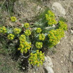
The section of Bob’s Trail covered by this wildflower walk description would provide an excellent community-based site-stewardship project, especially for nature-lovers living in nearby neighborhoods. Regular attention to the special native wildflowers that grow here, perhaps in combination with judicious weeding of non-native grasses that threaten to crowd them out, could make the difference in ensuring their continued survival here. A targeted effort to remove the most worrisome invasives, while their populations are still limited enough to make this feasible, would also be extremely beneficial. Prime candidates include the sulphur cinquefoil along the creek (as long as care is taken to leave Nuttall’s cinquefoil undisturbed) and whitetop at the edge of the dam. There is also a small but expanding population of myrtle spurge (Euphorbia myrsinites) at the base of the unofficial trail; the sooner this is removed, the better!
PLANT LIST [updating needed]
NOTE: Please enjoy the wildflowers and leave them for others to enjoy. Because our unique local flora is already under pressure from invasive weeds and habitat loss, harvesting of native plants is not encouraged on this website, especially along popular trails.
Plants listed alphabetically by genus within category. * indicates native species
WILDFLOWERS POSSIBLY IN BLOOM OR FRUIT
- *Yarrow (Achillea millefolium)
- Bird’s-foot trefoil, Spanish-clover (Acmispon americanus var. americanus; previously Lotus purshianus)
- *Fiddleneck (Amsinckia spp.) – species difficult to distinguish
- *Western or intermediate dogbane (Apocynum floribundum)
- *Woolly-pod milkvetch (Astragalus purshii var. glareosus)
- *Arrowleaf balsamroot (Balsamorhiza sagittata)
- Corn gromwell(Buglossoides arvensis)
- *Wingfruit or white mariposa/sego lily (Calochortus eurycarpus)
- *Sagebrush or green-banded mariposa/sego lily (Calochortus macrocarpus var. macrocarpus)
- *Common miner’s lettuce(Claytonia/Montia perfoliata, possibly other species as well)
- *Largeflower collomia (Collomia grandiflora)
- *Tapertip hawksbeard(Crepis acuminata)
- *Western hawksbeard (Crepis occidentalis)
- *Starry sulpher-flowered buckwheat(Eriogonum umbellatum var. ellipticum) – single clump protected by tree near trailhead, lower than typical elevation
- Stork- or cranesbill, filaree (Erodium cicutarium) – non-native
- *Cleavers, bedstraw, stickywilly, goose-grass (Galium aparine)
- *Curly-cup gumweed(Grindelia squarrosa)
- *Ballhead waterleaf, woolly-breeches (Hydrophyllum capitatum)
- Field pepperweed(Lepidium campestre)
- Lewis’s flax (Linum lewisii var. lewisii) – native to Idaho, but most (all?) populations in Boise foothills result from post-fire seeding
- *Narrowleaf biscuitroot (Lomatium simplex, previously included in L. triternatum, nine-leaf biscuitroot)
- *Longspur or polychrome lupine(Lupinus arbustus [= L. laxiflorus in older references])
- *Silver lupine(Lupinus argenteus)
- Alfalfa(Medicago sativa) – non-native
- Long-headed poppy or blindeyes (Papaver dubium) – possibly from “wildflower” mixtures
- *Silverleaf phacelia (Phacelia hastata var. hastata)
- *Longspur plectritis, Wedding-cake plant (Plectritis macrocera)
- *Nuttall’s or slender cinquefoil(Potentilla gracilis var. fastigiata)
- Curlydock (Rumex crispus) – non-native
- Small or garden burnet (Poterium sanguisorba var. polygamum, alternatively Sanguisorba minor) – non-native, frequently included in post-fire seeding mixes for livestock and wildlife forage
- Bouncingbet, soapwort (Saponaria officinalis) – non-native, probably not yet in bloom
- *Oregon checkermallow (Sidalcea oregana)
- *Sand fringepod (Thysanocarpus curvipes)
- *Foothill death-camas (Toxicoscordion/Zigadenus paniculatum)
- Yellow salsify or goat’s-beard (Tragopogon dubius)
- *Smallhead or maiden clover (Trifolium microcephalum)
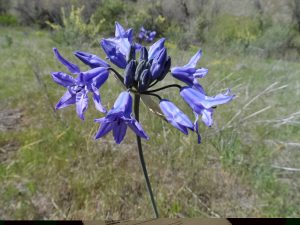
- *Wild-hyacinth, large-flowered triteleia, or Douglas’s brodiaea (Triteleia grandiflora, previously Brodiaea douglasii)
SHRUBS AND TREES (mostly not in bloom)
- *Basin big sagebrush (Artemisia tridentata ssp. tridentata)
- *Netleaf hackberry (Celtis reticulata)
- *Green rabbitbrush(Chrysothamnus viscidiflorus)
- *Rubber rabbitbrush (Ericameria [formerly Chrysothamnus] nauseosa)
- Juniper (Juniperus sp.) – bird-dispersed from cultivated plants
- *Syringa or Lewis’s mockorange(Philadelphus lewisii)
- *Black cottonwood (Populus trichocarpa) – other species and/or hybrids possibly present
- *Chokecherry(Prunus virginiana var. melanocarpa)
- *Bitterbrush, Antelope brush(Purshia tridentata)
- *Golden currant(Ribes aureum)
- Dog rose (Rosa canina) – non-native, with large hooked prickles, glabrous leaflets
- Obtuse- or Round-leaf dog rose (Rosa obtusifolia) – like dog rose, but leaflets hairy
- *Interior or Wood’s rose (Rosa woodsii ssp. ultramontana) – native, with slender prickles
- *Sandbar willow(Salix exigua)
- *Willows(Salix spp.) – several species locally, most are difficult to distinguish
- *Western poison-ivy (Toxicodendron rydbergii, alternatively Rhus radicans) – CAUSES DERMATITIS
GRASSES & GRASSLIKE PLANTS (not all in bloom, but evident)
- *Thurber’s needlegrass (Achnatherum/Stipa thurberianum)
- Crested wheatgrass (Agropyron cristatum) – intentionally introduced non-native
- *Threeawn grass (Aristida purpurea var. longiseta)
- Rattlesnake brome (Bromus briziformis)
- Bromes(at least two other Bromus species, difficult to identify)
- *Douglas’ sedge (Carex douglasii)
- *Sedge(Carex sp.) – numerous native species, difficult to tell apart
- *Common spike-rush (Eleocharis palustris)
- *Squirreltail grass (Elymus elymoides, formerly Sitanion hystrix)
- (*)Fescue (Festuca sp.) – possible both planted and native species
- *Needle-and-thread grass (Hesperostipa comata [previously Stipa])
- Mediterranean barley (Hordeum marinum ssp. gussonianum [= H. geniculatum])
- *Common toad rush (Juncus bufonius var. bufonius)
- *Straightleaf or pointed rush(Juncus orthophyllus)
- *Great Basin wildrye(Leymus/Elymus cinereus)
- Bulbous bluegrass (Poa bulbosa)
- *Sandberg bluegrass(Poa secunda)
- (*)Bluebunch wheatgrass (Pseudoroegneria spicata, alternatively in Agropyron or Elymus)
- Intermediate wheatgrass (Thinopyrum intermedium, alternatively in Elytrigia or Elymus)
- Rattail fescue(Vulpia/Festuca myuros) or similar species
SIGNIFICANT NOXIOUS WEEDS (some not yet in bloom, but evident)
- Jointed goatgrass(Aegilops cylindrica) – invasive non-native
- Cheatgrass (Bromus tectorum)
- Bachelor buttons, cornflower (Centaurea cyanus) – invasive non-native
- Rush skeletonweed (Chondrilla juncea)
- Field bindweed, wild morning-glory(Convolvulus arvensis)
- Mouse or wall barley (Hordeum murinum)
- Whitetop (Lepidium [previously Cardaria] draba)
- Sulphur cinquefoil(Potentilla recta)
- Tumble or Jim Hill mustard (Sisymbrium altissimum)
- Medusahead grass (Taeniatherum/Elymus caput-medusae)
- Ventenata or North African wiregrass (Ventenata dubia)
BOB’S TRAIL WILDFLOWER WALK
June